Writing contributions from our friends
The Choss Boys invite friends who have shared in their adventures to contribute stories from their own perspectives.
|
Another delectable trip report brought to you by Nick Hindley. This article was originally published 4 October 2020 on the University of British Columbia's Varsity Outdoors Club Blog and is reproduced here with Nick's Permission. Want more? Check out Nick's other post about our subsequent trip to Cathedral Provincial Park! Intermediate BushwhackingSunday, 5 July, to Tuesday, 7 July 2020 The Anderson River Group is one of Southwest BC’s many, many hidden gems. The access forest service road (FSR) is just a little over 2 hours from Vancouver, and the approach theoretically only takes half the day – depending on how far you can drive, and how fervently you can thwack. Therein lies the challenge. Our mode of transport was Nick Brown’s Honda C-RV. We were going to have to account for its meager clearance with either some tactful driving, or wreckless abandon. Nick B had a preference toward the former. Water bars started around 6 km up Anderson River (Cattermole) Main, and continued to worsen until a final creek crossing at around the 10-km mark. After spending some time navigating these obstacles and putting a couple fresh dents in the C-RV's catalytic converter, we arrived at a cluster of 3-8” diameter alders across the road. We still had a long way to go, and throwing our packs on here would add an additional 6 km to our hike. So we began stripping branches from the downed trees, and clearing as much debris from the road as possible. We rigged up a tensionless hitch to the first two trees using my 100-m, 10-mm Mammut static, then tripled it up to dissipate the load across three strands. We then hooked it up to the C-RV and gave her a tug. After some initial resistance, the fallen trees gave way with a snap at the base, and sprung across the road out of the way. Back in business. For the next few kilometers, the road was in reasonable shape, with frequent but manageable washouts, and occasional large washouts (~10.5km, ~12km), which are navigable for now due to the wide shoulder, but are unlikely to last more than a couple seasons longer. Around 13.5 km, the road narrows around a cliff and is rife with fresh rockfall. Daniel and I became the designated road clearing technicians, i.e. Dan jogged ahead and flung rocks off the road while I drank a few beers sitting on the C-RV's roof as we plodded up the FSR. We reached the definitive end of the drivable road 0.2 km after the Y-junction with Anderson Middle Main. 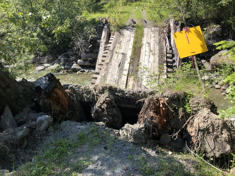 Bridge definitively OUT 200 m up Anderson Middle Main 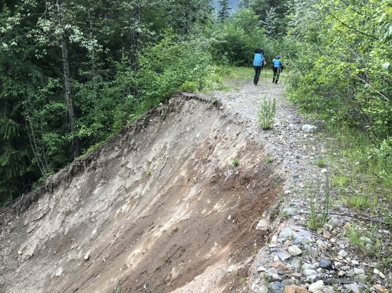 Large washout on road ~5km up Anderson Middle Main It was 15:30 when we left the vehicle behind, and from here it was a 6-km, uneventful logging road hike. We hauled in 5 days of supplies, and enough equipment and aid gear to keep our options open for a potential multiday bid or new route attempt. Our packs were heavy, and we took shifts carrying the frumpy 125-L haul bag. After only about an hour and a half, we reached the Steinbok branch that veers into the Valley. This marked the start of the thwackin’. For the next hour or so, we pushed and crawled through dense, relentless alder tunnels, with only occasional respite. It is on one of these instances that we caught our first glimpse of the mighty prow of Steinbok towering above – an impressive sight. We continued on Steinbok branch, beyond the N-600 turnoff, until we were more or less a straight shot east of Les Cornes. We battled uphill through every manner of thwack – brittle thickets, swampy marsh, and overgrown clearcuts – until we eventually gained the toe of a patch of old growth forest, giving rise to speedy and pleasant travel. As night fell and we donned headlamps, we scrambled up the talus and yarded through, under, and over the dense subalpine firs, finally arriving to the base of Les Cornes around 21:00. 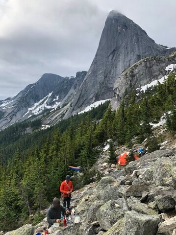 A base camp of sorts. Photo: Nick Hindley A base camp of sorts. Photo: Nick Hindley The bivy options were terrible. Icy snow and loose, poorly-sorted talus surrounded the base of the wall. With little desire to start carving a tent platform in the snow using nut tools and pot lids, Nick B and Dan claimed the only flat-ish spot to be found and began fashioning a talus platform that they lined with fir bows for comfort. Meanwhile, I opted for a long-hanging hammock among the firs – weary of stringing it too high and putting myself in the line of fire for detritus calving off from the wall above. 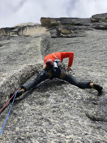 Nick Brown spreadin’ em on SCE pitch 1. Photo: Nick Hindley Nick Brown spreadin’ em on SCE pitch 1. Photo: Nick Hindley The next morning we set out from our camp at 09:00 and made the 1-h approach to the base of our route: Springbok Arete (5.11a) on Les Cornes. We opted for the Sprung Cock Erect ("SCE") variation, which adds 3 stellar pitches of 5.10b and c to the start. Snow buried the base of the route, so we avoided the lowest crux and jumped straight into the fingercrack to start out this excellent variation. The third pitch is especially memorable, with a few wild, exposed moves off the belay into a fine splitter. Daniel’s link-up of pitches 7 and 8 was an impressive feat, as he topped out pitch 8 – a burly 5.10+ offwidth – towing 50 meters of meandering rope drag below him (as if 5.10+ offwidth wasn’t enough). The following 5.8 traverse pitch is very fun, and a good opportunity to recuperate before the upcoming 5.11a crux. With a big reach up to a crucial fingerlock, we each fired through the 5.11a with gritted teeth followed by wide grins. Another superb pitch. We finished the route with a link up of pitches 11 and 12, for a full 60 m of 5.9 and a short scramble at the end. We traversed the exposed ‘au cheval’ around 19:30, and began our descent, which went off without a hitch. Once we reached the snow, we found a couple anchors along skiers right which we rapped from, to avoid an icy skitter down into the ‘schrund of sorts below. In summary, we were on route for about 8.5 hours, and linked/simul-climbed pitches 4+5, 7+8, and 11+12. The descent back to camp took us roughly 3 hours. Including the 1-h approach, it made for a 12.5-h outing camp-to-camp. The next day, the rains that we had feared may arrive came to fruition. An InReach weather forecast shutdown our optimism and cemented our decision to bail. We packed up our gear and food – much of which had not even been touched – and began the thwack back to the car. While it was a bummer to have hauled all the extra gear in there only to be rained out after 2 days, it came as no surprise. We were nevertheless stoked to have gotten in a very solid day of climbing on a quality route. On descent we shaved about an about an hour a half off of our approach time, being now familiar with the route and avoiding the worst of the thwack. We arrived back at the car in good time, leaving enough daylight to drive back into Hope for some diner chow and to plan the next leg of our trip. As you may have gathered, the access to the Anderson River Group is deteriorating. Rapidly. Back in the 1990’s, logging roads ran pretty much straight to the base of the walls. As recently as 4 years ago, it was still possible to drive to N-600 branch (see: Steph Abegg's TR). Now, this gem is guarded by deteriorating logging roads and tumultuous bushwhacking, slowly but surely fading deeper into obscurity. Another year or two will likely knock the road access back another 10 km. I’d encourage you to get in there while you still can; it is truly one of the more unique and aesthetic valley’s I’ve seen in BC, and as far as I know is not protected in any way. This place would benefit hugely from renewed access. The potential for new route development is widespread. Skiing potential is there, but yet to be confirmed. Did someone say VOC cabin...? 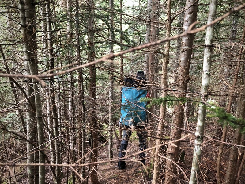 Un-thwacking.
2 Comments
Marie Wadden
10/15/2020 07:26:27 am
Thank-you for sharing this experience. What is a word for beyond awesome? You add many notches to the term “iron men.” Fabulous way to live on this Earth. 3/1/2024 11:02:56 pm
Pretty nice post. I just stumbled upon your weblog and wanted to say that I have really enjoyed browsing your blog posts. After all I’ll be subscribing to your feed and I hope you write again soon! Leave a Reply. |
Archives
October 2020
Categories |
 RSS Feed
